Contact Building Control

The Building Control Partnership are split into area teams. You may at times need to contact the specific team that covers the area you are in.
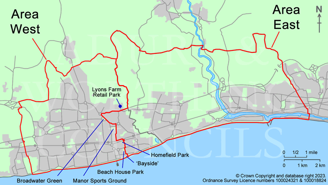
If you are not sure which team to contact refer to the area map below.
Please use the relevant contact details below:
Area West:
West and Central Worthing
Covers - all wards in Worthing except Broadwater and Selden
- Based at: Worthing Town Hall, Chapel Road, Worthing, West Sussex, BN11 1HA
- Tel: 01903 221068 or 01903 221418
- Text the word CALLBACK to 07537 415 761
- e-mail: building.control@adur-worthing.gov.uk
- or request an inspection online
Area East:
East Worthing, Sompting, Lancing, Shoreham-by-Sea and Southwick
Covers: all Adur wards; and Broadwater and Selden wards in Worthing
- Based at: Worthing Town Hall, Chapel Road, Worthing, West Sussex, BN11 1HA
(please note this team is based in Worthing) - Tel: 01903 221068 or 01903 221385
- Text the word CALLBACK to 07537 415 761
- e-mail: building.control@adur-worthing.gov.uk
- or request an inspection online
- Note: Appointments can also be arranged for Area East at:
The Shoreham Centre, Pond Road, Shoreham-by-Sea, West Sussex, BN43 5WU
Office hours
Office hours are:
- Monday to Friday: 9:00am to 5:00pm
Return to:
Map of areas covered by the teams:
See lists of roads below map for clarification on boundary lines.

Area West: West and Central Worthing
Covers - all wards in Worthing except Broadwater and Selden - if you are not sure what ward you live in please see below
Boundary line - from North to South (down the centre line of most roads listed below):
- west side of Lambleys Lane
- north side of the A27 Upper Brighton Road from Grove Lodge Roundabout to Lyons Farm Retail Park/Lambleys Lane
- west side of Broadwater Street West
- south side of Broadwater Street East up to Beaumont Road
- west side of Beaumont Road
- west side of Congreve Road
- alleyway between Livesay Crescent (included) and Garrick Road (excluded)
- west side of The Quashetts
- west side of Ivy Arch Road down to railway line
- properties in Station Road and Chesswood Road south of the railway line from subway to boundary of Chesswood Middle School (excluded)
- west side of Homefield Road (north of Lyndhurst Road)
- west side of Madeira Avenue
- Brighton Road - south side up to and including Bayside
- west side of Merton Road (including Bayside)
- across the beach to the sea
Area East: East Worthing, Sompting, Lancing, Shoreham-by-Sea and Southwick
Covers: all Adur wards; and Broadwater and Selden wards in Worthing - if you are not sure what ward you live in please see below
Boundary line - from North to South (down the centre line of most roads listed below):
- east side of Lambleys Lane
- south side of the A27 Upper Brighton Road from Grove Lodge Roundabout to Lyons Farm Retail Park/Lambleys Lane
- east side of Broadwater Street West
- north side of Broadwater Street East up to Beaumont Road
- east side of Beaumont Road
- east side of Congreve Road
- alleyway between Livesay Crescent (included) and Garrick Road (excluded)
- east side of The Quashetts
- east side of Ivy Arch Road down to railway line
- properties north of the railway line in King Edward Avenue from subway to boundary of Chesswood Middle School south of railway line (included)
- properties in east of Chesswood Road east of Chesswood Middle School (included) and south side east of Homefield Road
- east side of Homefield Road (north of Lyndhurst Road)
- east side of Madeira Avenue
- Brighton Road - north side opposite Bayside
- east side of Merton Road (excluding Bayside)
- across the beach to the sea
Not sure what ward you live in?
You can use Adur & Worthing mapping to see what ward your house or property is in by address (road name and/or number):

