Port health
Shoreham Port is a thriving commercial port on the south coast of England which lies within the boundaries of both Adur District Council and Brighton & Hove City Council. It serves as a key hub for cargo handling, marine services, commercial property, and leisure activities. It's one of the largest ports for landing shellfish in England, in particular the Great Scallop (Pecten maximus).
We are currently preparing content for webpages about:
- Fishing vessel hygiene (registration, inspection and registered list of vessels)
These will be added soon.
Map showing the main areas of Shoreham Port and the River Adur:
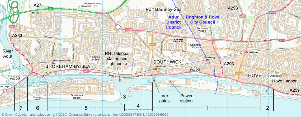
Click the map above for a larger zoomable image (on a mobile phone or a smaller screen)
- = the main port basin - the lock gates to the eastern end of the basin 'The Canal'
- = port access road, past Hove Lagoon to the A259
- = port entrance (harbour arms)
- = port entrance (harbour arms) to the lock gates
- = port entrance (harbour arms) to the Adur Ferry footbridge in Shoreham-by-Sea (the Western Harbour Arm)
- = Adur Ferry footbridge in Shoreham-by-Sea to the Norfolk Bridge (A259)
- = the mud flats (RSPB Wildfowl Reserve) beyond the Norfolk Bridge (A259)
The blue dashed line shows the border between Adur District Council and Brighton & Hove City Council.
See also: