The River Adur
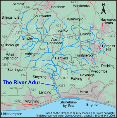
Maps of the River Adur and surrounding area:
See also:
You may also be interested in:
Introduction to the River Adur
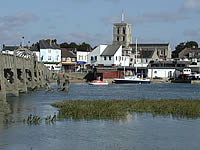
The River Adur derives its name from the Celtic word 'Dwyr', meaning 'water'. The river has been an important trade route since Roman times.
The Adur District gets its name from the River Adur which divides it roughly in half; with Shoreham-by-Sea, Southwick and Fishersgate to the east; and Lancing and Sompting and Coombes to the west.
During the 1700s and 1800s various new harbour entrances for the river were cut through the shingle, but all silted up again until the present river mouth at Kingston became permanent.
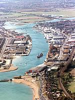
Today, Shoreham is still an important south coast port administered by Shoreham Port Authority. Principal cargoes include timber, refined oil and gravel dredged from the sea.
Two main separate arms form the River Adur:
- the Western Adur: Rising near Slinfold, the Western Adur flows through Shipley and West Grinstead
and - the Eastern Adur: Rises on Ditchling Common and flows north and west passing between Haywards Heath and Burgess Hill
Both arms then join near Henfield and flow south across the Henfield Levels, an area of unspoiled wetlands which draw dragonflies, damselflies and overwintering wetland birds.
Its final tidal route to the sea runs through the Shoreham Gap Valley, which is designated as an AONB (Area of Outstanding Natural Beauty).
Map of the route of River Adur from its sources to the sea
Local Nature Reserves (LNRs) and Sites of Special Scientific Interest (SSSIs) in the River Adur area
The Natural England website contains information about Local Nature Reserves (LNRs) and Sites of Special Scientific Interest (SSSIs) in the River Adur area. For more information see:
- Natural England - on the GOV.UK website
- Adur Estuary SSSI on the Natural England website
- LNRs on the Natural England section of the GOV.UK website
See also on our website:
- Lancing Ring Local Nature Reserve
- Mill Hill Local Nature Reserve
- Shoreham Beach Local Nature Reserve
- Widewater Lagoon
Ouse and Adur Rivers Trust
The River Adur Conservation Society and Sussex River Ouse Conservation Society have now been amalgamated to form the Ouse and Adur Rivers Trust.
For more information see the Ouse and Adur Rivers Trust.
Navigation and safety
Always remember that you are responsible for the safety of yourself and others when out and about on the water.
Make yourself familiar with the local regulations and signage before you venture out onto the water and remember to check the weather, wind and tide situation and forecasts as well. Ensure your craft is seaworthy and safe to use and has all the correct safety equipment, life jackets and communication devices as necessary - just in case you need them in an emergency.
Commercial shipping and large vessels in and around the harbour entrance, the harbour lock gates and the Shoreham Port areas can make it a potentially dangerous place to be and therefore possibly unsuitable for the inexperienced and those on small craft.
For more information about navigation and safety in and around Shoreham Port, the harbour area and entrance, the lock gates and the River Adur please see:
- Contact section of the Shoreham Port Authority website
- See also: Shoreham Harbour - on the Harbour Guides website
You can also contact the various sailing or water sports clubs detailed elsewhere on this page for other relevant navigation and safety information.
See also on our website:
Useful external websites:
- Tombstoning (involves jumping or diving from a height into water) - see: Tombstoning information - on the RoSPA website
- RNLI website: Youth education
- RNLI website: Safety and education
- Sail links website: Safety on the sea
- National Water Safety Forum website: Sea Safety
Moorings (including slipways, berths and marinas)
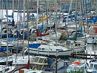
This section lists moorings available. To the best of our knowledge the information given is correct, but please check with the relevant authority or club for the current situation, access, costs and availability.
- Shoreham harbour river moorings and berths:
For visiting vessels are controlled and provided by Shoreham Port Authority in the locked canal section of the harbour. For more information see the Shoreham Port Authority website. - The Port's eastern arm:
Has 48 deep water moorings and Lady Bee Marina, in the main shipping channel, has 120 pontoon berths
For more information see the Lady Bee Marina on the Shoreham Port Authority website (label 13 on the map below) - Sussex Yacht Club and Sussex Motor Yacht Club:
Both have clubhouses in the harbour and there are 80 dry moorings, public slipways for small boats, alongside berths, and electricity at the western end of the Port on the banks of the River Adur. - For more information see the Sussex Yacht Club website (label 6 on the map below)
- Lady Bee Marina:
Has slipway, moorings, alongside berths, showers, toilets, water to boats, and lock gates.
Tel: 01273 591705 (contact: Graham Barnes)
For more information see the Lady Bee Marina on the Shoreham Port Authority website (label 13 on the map below) - Surry Boatyard:
Has moorings (label 8 on the map below)
Tel: 01273 461491 - Riverside Yard:
Riverside off Albion Street, Southwick, has berthing (label 14 on the map below)
Tel: 01273 592456 - Riverside Marine:
Has berthing and mooring (label 9 on the map below) - The Adur Water Activities Centre and Sea Scouts:
also have riverside premises and facilities on the west bank of the River Adur between Norfolk Bridge and the railway bridge (close to 1 on the map below)
See also: Shoreham Harbour - on the Harbour Guides website
Public access (including slipways and hards)
This section lists public access, slipways and hards available. To the best of our knowledge the information given is correct, but please check with the relevant authority or club for the current situation, access, costs and availability.
- Ropetackle Hard, also known locally as Little High Street Hard: Popular slipway, suitable for trailers. Free use to all (label 2 on the map below).
- Kingston Beach slipway: (currently closed) Wooden slipway near harbour mouth close to lifeboat station. Slipway only for canoes and dinghies. Fees payable to Shoreham Port Authority, Tel: 01273 598100 (label 12 on the map below).
- Emerald Quay slipway: Slipway on the Shoreham Beach side of the harbour, suitable for high tide use only. Contact Shoreham Port Authority, Tel: 01273 598100 (label 10 on the map below).
The following public hards can be affected by siltation and may be of marginal use, some have limited access at low tide and there are poor facilities to park vehicles close by for launching or retrieving:
- Ship Street Hard: opposite Ship Street (label 3 on the map below)
- Star Gap Hard: opposite Church Street (label 4 on the map below)
- Dolphin Hard / East Coronation Green Hard: opposite East Street (label 5 on the map below)
- Stowes Gap Hard: access to the hard is a public right of way for trolley wheeled access only across from the entrance way on Brighton Road, there is no parking available.
Please note, the slipway within the perimeter of the Sussex Yacht Club car park is a private slipway and for the use of club members only - see Sussex Yacht Club website (label 6 on the map below) - Tarmount Hard: this has now been filled in and is being redesignated as a restricted byway (label 7 on the map below)
Map of places of interest on the River Adur and Shoreham Harbour
Map showing approximate locations of slipways, hards, marinas, boatyards, sailing and yacht clubs and other places of interest on the River Adur and in Shoreham Harbour.
Please note:
- not all locations shown on the map below are public access
- more details on other available public slipways are listed below
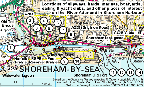
Locations shown on map above:
1. Adur Outdoor Activity Centre (also Adur Canoe Club, Adur Water Activities Centre and the Sea Scouts)
2. Ropetackle Hard slipway, also known locally as Little High Street Hard slipway - hard owned by West Sussex County Council
3. Ship Street Hard slipway (opposite Ship Street) - hard owned by West Sussex County Council
4. Star Gap Hard slipway (opposite Church Street) - hard owned by West Sussex County Council
5. Dolphin Hard slipway, also known locally as East Coronation Green slipway (opposite East Street) - hard owned by West Sussex County Council
6. Stowes Gap Hard - access to the hard is a public right of way for trolley wheeled access only across from the entrance way on Brighton Road, there is no parking available - hard owned by Sussex Yacht Club
6. Sussex Yacht Club - please note, the slipway within the perimeter of the club car park is a private slipway and for the use of club members only - see Sussex Yacht Club website
7. Tarmount Hard (to the east of Sussex Yacht Club) - this has now been filled in and is being redesignated as a restricted byway - owned by Sussex Yacht Club
8. Surry Hard slipway (opposite Surry Street / New Road junction) - hard owned by West Sussex County Council
8. Surry Boatyard (opposite Surry Street / New Road junction)
9. Riverside Marine
10. Emerald Quay slipway
11. Shoreham Sailing Club - see Shoreham Sailing Club website
12. Kingston Beach slipway
12. Shoreham Rowing Club - see Shoreham Rowing Club website
12. Shoreham Harbour RNLI lifeboat station and Shoreham Lighthouse
13. Lady Bee Marina - see Marinas - on Shoreham Port website
14. Riverside Yard
See also:
Frequently asked questions about the River Adur
The information in this section has been provided by the Environment Agency, West Sussex County Council as well as Adur & Worthing Councils.
In this section West Sussex County Council's name has been abbreviated to WSCC throughout.
See also:
Other websites:
Who looks after the River Adur?
The Environment Agency have the most statutory duties and responsibilities regarding water quality, water resources, Biodiversity, flood risk management, etc.
The Estuary is a Site of Special Scientific Interest (SSSI) so Natural England are also very much involved.
Much of the Estuary is owned by the RSPB who have a large Wildfowl Reserve on the River Adur.
See also:
- Bathing water quality monitoring - Seawater
- RSPB River Adur Estuary Wildfowl Reserve - on the RSPB website
- RSPB website
- Environment Agency contacts - on the GOV.UK website
- Natural England website
Back to Frequently Asked Questions or Back to top
Who is responsible for, and manages, the public hards and slipways?
Public hards are the responsibility of WSCC above, or down to, the high watermark (ie the dry bit): This responsibility is for the maintenance of the surface and construction of the hard but it does not necessarily extend to removing slime or debris. Public hards are public launching facilities. If the public find any hard obstructed then they can report this to WSCC - Public Rights of Way. For more details see Public rights of way on the WSCC website.
Public hards/slipways below high watermark (ie the wet bit): are the responsibility of Shoreham Port Authority.
In general terms street cleansing is the responsibility of Adur District Council however it is reasonable to expect that surfaces which are continually immersed in water by tidal action will not be in the same condition as would be expected for a pavement in say a town centre shopping area.
The Kingston Beach slipway is cleaned 18 times a year and this is undertaken by a contractor.
The Environment Agency does not own or operate any public slipways on the river.
Obstructions, such as vehicles or boats, are a matter for Sussex Police under the 'Road and Traffic Regulation Act and/or the Highways Act, 1980'. It is also possible for WSCC to take action on obstructions that are not motorised vehicles. Enforcement action is also possible via Adur District Council for abandoned vehicles and/or trailers/caravans or any other large object causing a nuisance in a public space. See also our Abandoned vehicles webpage.
Many of the public hards are of marginal use to the public. These hards or slipways are really remnants of historic times when there was much more economic activity dependent on the river and the harbour, eg: fishing / shell fishing / boat building, etc.
Nowadays, the businesses located around the hards tend not to be dependent on access to the water and the slipways are silted up or inaccessible because of a lack of facilities such as parking.
See also:
- Environment Agency - on the gov.uk website
- Shoreham Port Authority website
- West Sussex County Council website
- Public access - including slipways and hards (above)
Back to Frequently Asked Questions or Back to top
What if a boat is speeding on the River Adur? Who should it be reported to?
Speed limits are in place on the River Adur as the wash caused by boats has an impact on flood defences and river banks.
Downstream of the Old Shoreham Toll Bridge contact Shoreham Port Authority.
Upstream of the Old Shoreham Toll Bridge there is no Navigation Authority, but the River is maintained by the Environment Agency.
For details of the maximum size of boats that can can navigate upstream to the confluence of the eastern and western branches of the Adur, please see:
Back to Frequently Asked Questions or Back to top
Who is responsible for the bridges over the River Adur?
The Shoreham Footbridge (from High Street to Ferry Road, Shoreham Beach) is the responsibility of WSCC. It can be opened to allow large boats and vessels through. Any requests for the bridge to be opened to shipping must be made in writing to the:
Bridges across the main River Adur in the Adur District (listed in order from the sea heading upstream) are:
- Adur Ferry Bridge - the foot bridge linking Shoreham Beach to Shoreham High Street - owned by WSCC
- Norfolk Bridge (carrying the A259 next to Ropetackle) - owned by WSCC
- Railway bridge - owned by Network Rail
- The Old Shoreham Toll Bridge - owned by WSCC
- A27 flyover - owned by the Highways Agency
Bridges north of this are outside the Adur District - the next few bridges up the River Adur are in Horsham District and include:
- Footbridge (St. Botolph's Bridge) from Botolphs to Dacre Gardens, which carries the South Downs Way and Downs Link routes - owned by WSCC
- A283 (Steyning by-pass) bridge - owned by WSCC
- The Street, Bramber / High Street, Upper Beeding bridge (C176) - owned by WSCC
- Footbridge north of Upper Beeding - owned by WSCC
Other small bridges and crossings may also be over the many small streams and tributaries that run into the main River Adur. These would most likely not be publicly accessible, as they are on private land or farms, and would therefore probably be the responsibility of the landowner or farmer.
See also our:
See also external websites:
Back to Frequently Asked Questions or Back to top
What if a boat crashes into a bridge over the River Adur?
In the event of an emergency the main emergency services (police, fire, ambulance, coastguard, etc) should be contacted by dialling 999.
It depends on who owns the bridge - most are owned by West Sussex County Council, but some of the bridges belong to other authorities. The relevant authority would need to be informed.
The Environment Agency doesn't own any bridges on the River Adur, but it does need to be notified in the event of an incident:
See also: Bridge ownership in the question above
Back to Frequently Asked Questions or Back to top
Who rescues people from the River Adur or from the Harbour?
In the event of any emergency the main emergency services (police, fire, ambulance, coastguard, etc) should be contacted by dialling 999.
In the harbour entrance and river mouth it is probably the RNLI and the main emergency services who will respond.
Further up the river it would probably fall to the main emergency services to respond.
Sailing, yachting and water sport/activity clubs would also probably be on hand if the problem was to do with an event or training they were involved in organising or running, or was near to an event they were running at that time.
Back to Frequently Asked Questions or Back to top
What happens if a boat sinks in the River Adur or in the Harbour?
In the event of an emergency the main emergency services (police, fire, ambulance, coastguard, etc) should be contacted by dialling 999.
The owner would be responsible for notifying the relevant bodies that it had sunk.
Removal would be then undertaken either by the Port Authority or the Environment Agency. Ultimately, they would seek to recover costs from the owner or the owner's insurance. If the sunken craft is not causing a hazard or obstruction to the flow or navigation of the river or the structures (bridges) in it then its removal would probably not be regarded as a matter of urgency.
See also:
Back to Frequently Asked Questions or Back to top
Do I need a boat licence to take my boat on the River Adur?
There is a common law right of navigation on the tidal reaches on the River Adur (ie from the river mouth upstream as far as Shermanbury). No licences are required, though there may be fees payable to the Port Authority if navigating or launching within the harbour area, or to a club or organisation if using their private slipway.
Back to Frequently Asked Questions or Back to top
Can I go fishing in the River Adur?
The middle reaches of the river support a good mixed coarse fishery, with species such as Roach, Dace and Chub present.
The upper tidal reaches also have good mixed coarse fishing, including bream, carp and pike. In the lower tidal section, mullet, bass and flounder can also be encountered.
The River Adur also supports a good annual run of sea trout, which migrate in from the sea during summer months and spawn on the gravel beds in winter.
Anglers (aged 12 years or over) fishing for salmon, trout, freshwater fish or eels in England (except the River Tweed), Wales or the Border Esk and its tributaries in Scotland, must have a fishing rod licence.
Note:
- Upstream from Streatham Bridge (near Small Dole) you must be a member of Henfield & District Angling Society.
- Downstream from Streatham Bridge (near Small Dole) you must be a member of Pulborough Angling Society.
For more information on how to apply for a licence, see:
Illegal shellfish gathering on the River Adur
Reports have been received of people in large groups, collecting cockles and mussels from the River Adur in the Norfolk Bridge area. The public are warned that shellfish gathered from this area are likely to be unfit for human consumption due to high levels of contaminants in the water, such as the bacterium E.coli, leading to possible serious illness if consumed.
This area is not classified under food safety regulations to permit the harvesting of shellfish and it is an offence to remove any shellfish for the purpose of commercial supply or sale.
The area is also a Site of Special Scientific Interest (SSSI) and fauna and flora should not be disturbed.
If any person has information that contaminated shellfish harvested from the River Adur is entering the food chain and can provide details of persons seen removing shellfish from this area (the individuals should not be approached), please report to us using the form below:
Send it to:
- Public Health & Regulation,
Adur & Worthing Councils,
Worthing Town Hall,
Chapel Road,
Worthing,
West Sussex,
BN11 1HA
or email: publichealth.regulation@adur-worthing.gov.uk
Telephone: 01903 221064

Need assistance with this service?
Get in touch:
Adur enquiries
Worthing enquiries
Page last updated: 04 April 2024


 01273 263000
